- Basel Jura and Aargau Jura. Change
from table Jura to
folded Jura 1:100 000
Original watercolor for a map in the
Schweizerischer Mittelschulatlas, 1929. Editions 1932-1976.
Watercolor
on print of the topographical situation. 14 x 17 cm.
(Imhof,
Eduard F 13)
|
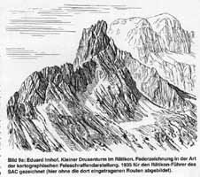
- Kleiner Drusenturm in the Raetikon (Rhaetian Alps).
View
of a rocky peak, sketched by pen in the style of cartographic
rock drawing by E. Imhof. 1935. As shown in:
E. Imhof,
Cartographic Relief Presentation. Berlin 1982, and in:
E.
Imhof, Rätikon. o. O. 1936. = Clubführer durch die Bündner
Alpen, Band 7. (Imhof, Eduard O 17)
|